Rainy periods late Tuesday; Warm midweek

A dissipating cold front is moving toward our area and bringing cloudy skies. Showers over the Upper Peninsula and Wisconsin have weakened as they progress eastward. Tuesday will start with partly cloudy skies, then cloud cover will increase. A storm system coming out of Texas and New Mexico will move toward the northeast and bring a chance of rain late Tuesday.
Future rainfall through predawn Wednesday is showing that most of Northeast Michigan will get up to one-third inch of rainfall.

Most of Tuesday will be dry, then the chance of rain will increase in the evening. Wednesday will be mainly dry with partly cloudy skies. The next chance of rain will move in midday Thursday with a cold front. Temperatures will become notably colder Friday.

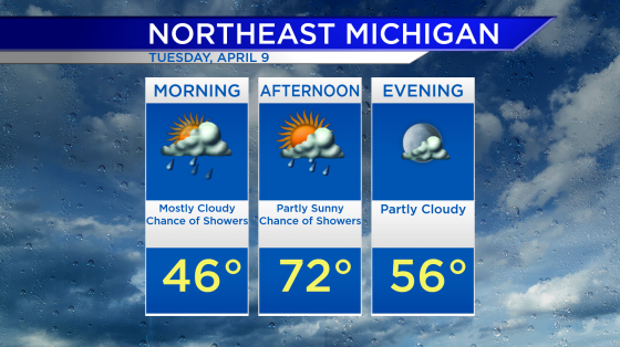
Tuesday: A mix of sun and clouds early, then cloudy in the afternoon, followed by evening rain. Predawn temperatures will be in the middle 50s. Temperatures will rise to the middle 60s in the late-morning. Afternoon highs will get up to 76 degrees. Early-evening temperatures will be in the upper 60s.
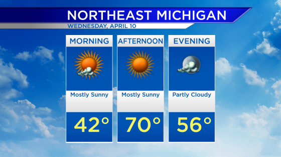
Wednesday: A chance of rain will end before daybreak, then partly cloudy. Low temperatures will be in the upper 50s predawn. Late-morning temperatures will be in the middle/upper 60s. Afternoon highs will reach about 80 degrees. Early-evening temperatures will be in the lower 70s.
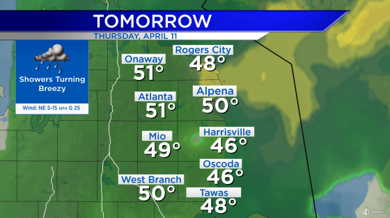
Thursday: Showers will move through Northeast Michigan midday-afternoon. Winds will strengthen — initially coming from the south, then later coming from the west at 15-20 mph. Early-morning lows will be in the middle 60s. Afternoon highs will be near 81 degrees. Early-evening temperatures will be close to 70 degrees.

For the rest of Northeast Michigan’s weather forecast, watch the latest weather video by clicking the weather tab at the top of the page.