Rainy weekend; Risk of thunderstorms late-day Sunday
High temperatures today reached the lower 60s for most of Northeast Michigan. However, places to the southwest and away from Lake Huron got warmer temperatures in the middle and upper 60s. Light winds out of the east caused cooler temperatures at the shoreline were high temperatures reached the upper 50s. Temperatures will get colder tomorrow while our area remains stuck north of a warm front (air is drastically warmer to the south of a warm front).

Rain showers to our southwest will move into our area early tomorrow. On and off showers are expected during the daytime, so there will be some occasional breaks from the wet weather, then Steady rain is expected tomorrow evening. On Sunday, a secondary storm system will be on the move from Kansas to Lake Michigan — Sunday will start with some showers, then thunderstorms are likely beginning in the mid-afternoon and lasting until the evening.
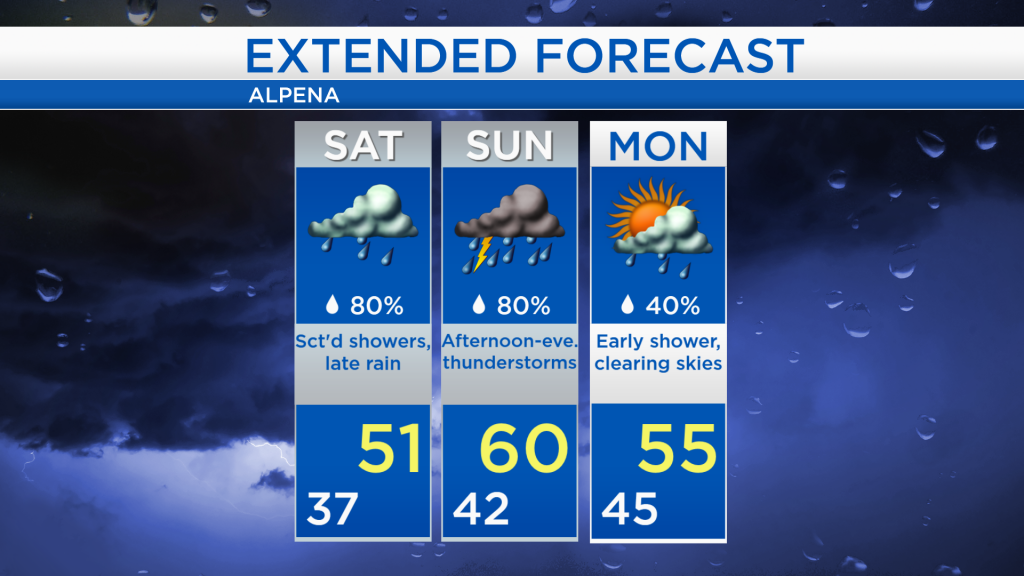
For tomorrow, a few showers are expected during the daytime then some steadier rain is likely during the evening. High temperatures will reach only the lower 50s with a breeze out of the east.

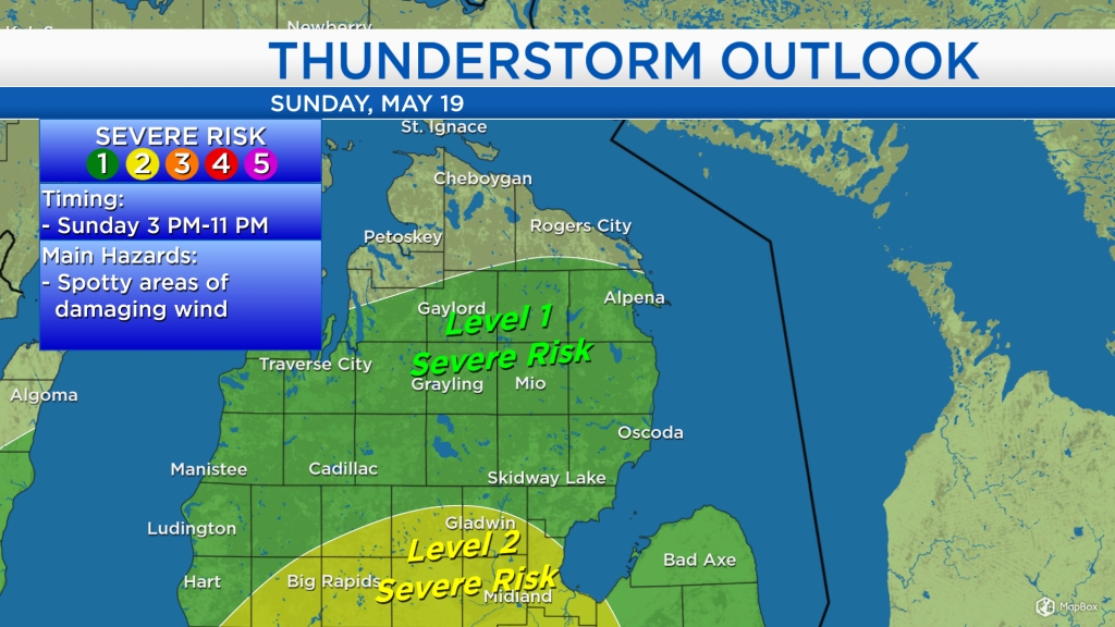
On Sunday, the risk of thunderstorms is greatest from 3 p.m. until 11 p.m. including the potential for localized damaging winds. The Storm Prediction Center has placed our area under a Level 1 risk of severe thunderstorms for Sunday afternoon and evening (shown in dark green). A level 2 risk (in yellow) is highlighted just to the south of our area, including places close to Saginaw Bay. The risk of severe thunderstorms on Sunday is greater south, and lower north.
Rainfall is likely both tomorrow and Sunday, although amounts will be greater with the thunderstorms on Sunday. About 0.25-0.5 inches of rain is forecast for Saturday, then additional rainfall amounts on Sunday will likely get close to 1 inch. A chance of showers will linger Monday morning, then clearing will begin Monday midday.
Tomorrow will be colder and damp. The most impactful weather will occur Sunday afternoon and evening with a risk of thunderstorms and greater rainfall amounts. High temperatures on Sunday will likely reach close to 60 degrees in Alpena, although a wide range of temperatures is likely — ranging from the 50s in Presque Isle County to the 70s in Ogemaw County. Temperatures will drop slightly on Monday with highs in the middle 50s, then warmer temperatures are expected for the middle end of next week. For the rest of Northeast Michigan’s weather forecast, watch the latest weather video by clicking the weather tab at the top of the page.