
Rain arrives Wednesday afternoon; Much colder late-week
A weak cold front moved through Northern Michigan today, which set off a few showers from 5 to 9 p.m. earlier this evening. Dry weather will take over tonight and continue to Wednesday morning. The next storm system currently located over Montana and Idaho will move into the Great Lakes. It will bring showers starting Wednesday afternoon, becoming steadier rain late-day.
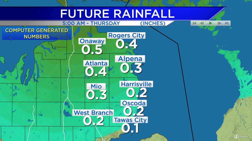
Rainfall amounts Wednesday afternoon through early Thurdsay will be greatest north of Alpena and less south of Alpena. About a half-inch of rain is expected in Presque Isle County. Around Alpena, close to one-quarter of an inch is likely. Near Tawas City, rainfall only looks to reach about one-tenth of an inch.

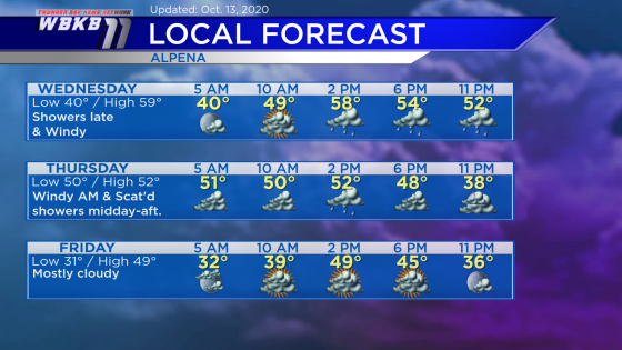
Wednesday: Increasing clouds early, then periods of rain will arrive in the afternoon and continues into the evening. Winds will increase late-day. Early-morning temperatures will be near 40 degrees. Temperatures will rise to about 50 degrees in the late-morning. Afternoon highs will be close to 59 degrees. Early-evening temperatures will be in the lower 50s.
Thursday: A chance of scattered showers midday-afternoon, otherwise mostly dry and cloudy. Windy in the morning and afternoon, out of the west around 20 mph. Early-morning temperatures will be near 50 degrees. Temperatures will not budge much, reaching only the lower 50s in the afternoon. Early-evening temperatures will cool to the middle 40s.
Friday: Mostly cloudy, and much colder air arrives early. Predawn temperatures will drop to the lower 30s. Late-morning temperatures will be near 40 degrees. Afternoon highs will be around 49 degrees. Early-evening temperature will be in the lower 40s.
For the rest of Northeast Michigan’s weather forecast, watch the latest weather video by clicking the weather tab at the top of the page.


