Cold front and gusty winds move in Thursday
Mainly clear skies tonight will give way to increasing cloud over early Thursday. A cold front currently located near the U.S.-Canada border will head into the Upper Peninsula first then slide across our area around midday/afternoon. The cold front will bring a quick round of showers and gusty winds.
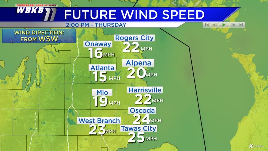
Wind speeds will increase Thursday morning. By the afternoon, sustained winds will be close to 20 mph for most places (locally higher). In addition to the numbers plotted on the map below, there will be occasionally higher wind gusts. Friday will be a little breezy but not as windy. Wind speeds will become calmer Friday evening/overnight.
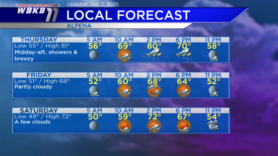
Thursday: Increasing clouds in the morning, midday-afternoon showers. Occasional wind gusts will become greater than 30 mph. Early-morning temperatures will start in the middle 50s. Temperatures will get close to 70 degrees in the late-morning. Afternoon highs will warm to about 81 degrees. Early-evening temperatures will be in the upper 60s.
Friday: Partly cloudy and colder. Predawn temperatures will be in the lower 50s. Late-morning temperatures will be near 60 degrees. Afternoon highs will get up to only 68 degrees. Early-evening temperatures will be in the lower 60s.
Saturday: A few clouds, and it will be the brightest day of the Labor Day weekend. Predawn temperatures will drop to the upper 40s. Late-morning temperatures will be around 60 degrees. Highs will reach about 72 degrees in the afternoon. Early-evening temperatures will be in the middle 60s.
For the rest of Northeast Michigan’s weather forecast, watch the latest weather video by clicking the weather tab at the top of the page.


